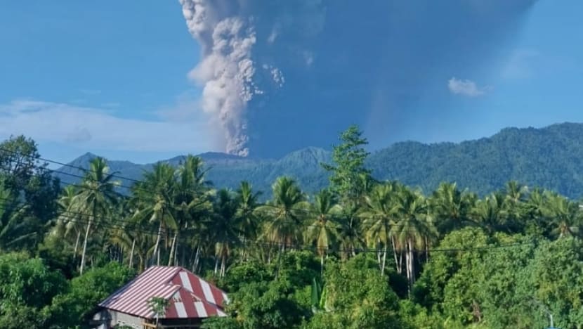
Mount Dukono, located in North Maluku province, erupted on Friday morning, sending a smoke cloud 10km into the air.

JAKARTA: Indonesian authorities are still trying to locate three missing hikers after rescuing 17 people trapped by the volcanic eruption of Mount Dukono on Halmahera island on Friday (May 8), a local rescue agency official told Reuters.
The eruption on Halmahera island sent an ash cloud about 10km into the air, with no towns of villages near enough to face any immediate threat.
The local rescue agency earlier said that 20 hikers were trapped by the eruption, including nine Singaporeans and 11 Indonesians.
Iwan Ramdani, the head of the local rescue agency, told Reuters that 17 had been found and evacuated. It is unclear how many Singaporeans were rescued.
Iwan said the search is still on for the three hikers who remain missing.
Survivors said three people, including two Singaporeans, died in the eruption, local police chief Erlichson Pasaribu told Reuters. But the rescue agency has yet to confirm the deaths.
The bodies of the deceased were still on the mountain, he added.
ADVERTISEMENT
“Due to ongoing eruptions, the situation is still considered unsafe for evacuation. So, the joint team is still waiting for the right time to begin the search,” Erlichson said.
Some of the hikers had suffered minor injuries and were taken to hospital for treatment.
The group’s guide and a porter were taken to the police station and could face criminal charges for taking hikers into a prohibited area, added the police chief.
Mount Dukono, located in North Maluku province, erupted on Friday at 7.41am local time (6.41am, Singapore time), sending a smoke cloud 10km into the air.
Lana Saria, head of the government Geology Agency, said the early-morning eruption was accompanied by a “booming sound” and a thick smoke column rising around 10 kilometres from the summit of Mount Dukono.
“The direction of the ash distribution leans northward, so residential areas and Tobelo City need to be vigilant for… volcanic ash rain,” she said in a statement.
The smoke could be dangerous for public health, Lana added, and risked disrupting transportation services.
There are no settlements within a radius of about 9km from the volcano.
CONTENT CREATORS
Since December, the Center for Volcanology and Geological Hazard Mitigation (PVMBG) has recommended that tourists and climbers do not come within 4km of the volcano’s Malupang Warirang Crater.
Unlike Indonesia’s more tourist-friendly volcanoes, Mount Dukono sits far from the country’s main travel routes. Reaching it from Jakarta typically involves flights to Ternate, a boat crossing to Halmahera, and a long overland drive to Tobelo in North Halmahera before the trek even begins.
Hikers typically travel through dense forest before reaching barren volcanic terrain coated in ash and sulfur deposits.
Erlichson said the hikers had ignored social media appeals and warning signs put up at the entrance to the trail to stay away.
“Local residents understand and don’t want to climb. Many (hikers) are foreign tourists who wish to create (social media) content.”
Erlichson urged hikers to stay away to avoid a repeat of Friday’s avoidable disaster that has forced rescuers to deploy into in “tough terrain” even as the volcano continues rumbling.
“After this incident, we will be strictly monitoring posts that hikers can pass. So no hiking as long as the status remains at level 2,” he said.
Indonesia, a vast archipelago nation, experiences frequent seismic and volcanic activity due to its position on the Pacific “Ring of Fire” where tectonic plates collide.
The Southeast Asian country has nearly 130 active volcanoes.
Mount Dukono, one of three volcanoes on the Halmahera Island. It has been erupting continuously since 1933, with frequent ash explosions and sulfur dioxide plumes.
Source: CNA

